
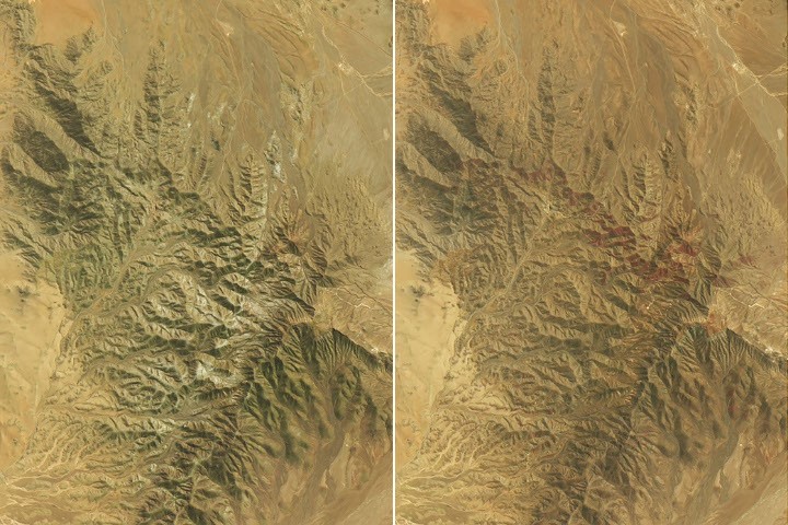
The Atacama Desert in northern Chile, widely recognized as one of the most arid environments on the planet, underwent a dramatic transformation in the spring of 2026. Following an unusually wet winter, vast stretches of the landscape erupted in vibrant shades of red, purple, green, and white. This phenomenon, known as the desierto florido or “flowering desert,” is driven by the germination of seeds that typically lie dormant in the soil for years, waiting for sufficient moisture to bloom.
Satellite imagery captured by the Landsat 8 and Landsat 9 missions reveals the scale of this event, which researchers suggest may be the most extensive flowering recorded since the beginning of the satellite era. The transformation was particularly visible in areas southwest of Copiapó, where the landscape shifted from barren terrain to a dense carpet of vegetation between mid-September and late October.
The Role of El Niño and Atmospheric Rivers
The unusual rainfall that triggered this biological surge was linked to shifting climate patterns in the Pacific. As El Niño conditions strengthened, the subtropical Pacific high—a pressure system that normally maintains the Atacama’s extreme dryness—weakened. Simultaneously, a blocking high formed near the tip of South America, effectively pushing the Southern Hemisphere’s storm track toward the equator.
This atmospheric shift allowed a series of storm fronts, fueled by an atmospheric river, to deliver significant precipitation across Chile starting in mid-July. According to the Dirección Meteorológica de Chile, this was one of the heaviest July rain events in decades. The moisture was further bolstered in August by back-to-back winter storms that brought rare snowfall to parts of the desert, providing the deep hydration necessary for the subsequent spring bloom.
Mapping the Biodiversity of the Bloom
To better understand the ecological impact of these rains, scientists from the Pontificia Universidad Católica de Valparaíso have been conducting field research alongside satellite analysis. By utilizing drones, digital cameras, and multispectral remote sensing, the team is mapping the biodiversity of the bloom to assist conservation managers and land-use planners.
The colorful displays are composed of specific desert flora, including:
- Pata de guanaco: Identified as Cistanthe longiscapa or related species, these plants created the prominent red-purple expanses observed in late October.
- Suspiros: Identified as Nolana baccata, these plants contributed the green and white hues observed earlier in the season, particularly on the hillsides.
A Historic Event in the Satellite Record
The 2026 flowering event is notable not just for its visual impact, but for its scale. While previous studies have used NASA’s long-term vegetation records to identify 13 distinct blooms between 1981 and 2015, the current event appears to surpass them all. Andres Moreira-Muñoz, a plant geography scientist involved in the research, noted that the 2026 bloom is the most significant to date in terms of its intensity, duration, and geographic extent since remote sensing data became available.
This ongoing research, supported by the Fondecyt Regular Project, highlights the importance of satellite data in monitoring how climate-driven moisture events reshape desert ecosystems. By documenting these rare occurrences, scientists are gaining a clearer picture of how the Atacama’s dormant biodiversity responds to the shifting influence of global climate phenomena like El Niño.
